目录结构
随着移动终端的普及,很多应用都基于LBS功能,附近的某某(餐馆、银行、妹纸等等)。
基础数据中,一般保存了目标位置的经纬度;利用用户提供的经纬度,进行对比,从而获得是否在附近。
目标:
查找附近的某某某,由近到远返回结果,且结果中有与目标点的距离。
针对查找附近的某某某,提出两个方案,如下:
一、方案A:
1、推导
通过余弦定理以及弧度计算方法,最终推导出来的算式A为:
$s = acos(cos($radLat1) cos($radLat2) cos($radLng1 - $radLng2) + sin($radLat1) sin($radLat2)) $R;
目前网上大多使用Google公开的距离计算公司,推导算式B为:
$s = 2asin(sqrt(pow(sin(($radLat1-$radLat2)/2),2)+cos($radLat1)cos($radLat2)pow(sin(($radLng1-$radLng2)/2),2)))$R;
其中 :
$radLat1、$radLng1,$radLat2,$radLng2 为弧度
$R 为地球半径
2、两种算法
通过测试两种算法,结果相同且都正确,但通过PHP代码测试,两点间距离,10W次性能对比,自行推导版本计算时长算式B较优,如下:
//算式A
0.56368780136108float(431)
0.57460689544678float(431)
0.59051203727722float(431)
//算式B
0.47404885292053float(431)
0.47808718681335float(431)
0.47946381568909float(431)
3、所以采用数学方法推导出的公式:
<?php//根据经纬度计算距离 其中A($lat1,$lng1)、B($lat2,$lng2)public static function getDistance($lat1,$lng1,$lat2,$lng2) {//地球半径$R = 6378137;//将角度转为狐度$radLat1 = deg2rad($lat1);$radLat2 = deg2rad($lat2);$radLng1 = deg2rad($lng1);$radLng2 = deg2rad($lng2);//结果$s = acos(cos($radLat1)*cos($radLat2)*cos($radLng1-$radLng2)+sin($radLat1)*sin($radLat2))*$R;//精度$s = round($s* 10000)/10000;return round($s);}?>
4、实际应用中
在实际应用中,需要从数据库中遍历取出符合条件,以及排序等操作,将所有数据取出,然后通过PHP循环对比,筛选符合条件结果,显然性能低下;所以我们利用下Mysql存储函数来解决这个问题吧。
1)、创建MySQL存储函数,并对经纬度字段建立索引
DELIMITER $$CREATE DEFINER=`root`@`%` FUNCTION `GETDISTANCE`(lat1 DOUBLE, lng1 DOUBLE, lat2 DOUBLE, lng2 DOUBLE) RETURNS doubleREADS SQL DATADETERMINISTICBEGINDECLARE RAD DOUBLE;DECLARE EARTH_RADIUS DOUBLE DEFAULT 6378137;DECLARE radLat1 DOUBLE;DECLARE radLat2 DOUBLE;DECLARE radLng1 DOUBLE;DECLARE radLng2 DOUBLE;DECLARE s DOUBLE;SET RAD = PI() / 180.0;SET radLat1 = lat1 * RAD;SET radLat2 = lat2 * RAD;SET radLng1 = lng1 * RAD;SET radLng2 = lng2 * RAD;SET s = ACOS(COS(radLat1)*COS(radLat2)*COS(radLng1-radLng2)+SIN(radLat1)*SIN(radLat2))*EARTH_RADIUS;SET s = ROUND(s * 10000) / 10000;RETURN s;END$$DELIMITER ;
2)、查询SQL
通过SQL,可设置距离以及排序;可搜索出符合条件的信息,以及有一个较好的排序
SELECT *,latitude,longitude,GETDISTANCE(latitude,longitude,30.663262,104.071619) AS distance FROM mb_shop_ext where 1 HAVING distance<1000 ORDER BY distance ASC LIMIT 0,10
二、方案B:Geohash算法
Geohash算法是一种地址编码,它能把二维的经纬度编码成一维的字符串。比如,成都永丰立交的编码是wm3yr31d2524
优点:
1)、利用一个字段,即可存储经纬度;搜索时,只需一条索引,效率较高
2)、编码的前缀可以表示更大的区域,查找附近的,非常方便。 SQL中,LIKE ‘wm3yr3%’,即可查询附近的所有地点。
3)、通过编码精度可模糊坐标、隐私保护等。
缺点:
1、geohash的编码算法
成都永丰立交经纬度(30.63578,104.031601)
1)、纬度范围(-90, 90)平分成两个区间(-90, 0)、(0, 90), 如果目标纬度位于前一个区间,则编码为0,否则编码为1。
由于30.625265属于(0, 90),所以取编码为1。
然后再将(0, 90)分成 (0, 45), (45, 90)两个区间,而39.92324位于(0, 45),所以编码为0
然后再将(0, 45)分成 (0, 22.5), (22.5, 45)两个区间,而39.92324位于(22.5, 45),所以编码为1
依次类推可得永丰立交纬度编码为101010111001001000100101101010。
2)、经度也用同样的算法,对(-180, 180)依次细分,(-180,0)、(0,180) 得出编码110010011111101001100000000000
3)、合并经纬度编码,从高到低,先取一位经度,再取一位纬度;得出结果 111001001100011111101011100011000010110000010001010001000100
4)、用0-9、b-z(去掉a, i, l, o)这32个字母进行base32编码,得到(30.63578,104.031601)的编码为wm3yr31d2524。
11100 10011 00011 11110 10111 00011 00001 01100 00010 00101 00010 00100 => wm3yr31d2524
十进制 0 1 2 3 4 5 6 7 8 9 10 11 12 13 14 15
base32 0 1 2 3 4 5 6 7 8 9 b c d e f g
十进制 16 17 18 19 20 21 22 23 24 25 26 27 28 29 30 31
base32 h j k m n p q r s t u v w x y z
2、策略
1)、在纬度和经度入库时,数据库新加一字段geohash,记录此点的geohash值
2)、查找附近,利用 在SQL中 LIKE ‘wm3yr3%’;且此结果可缓存;在小区域内,不会因为改变经纬度,而重新数据库查询
3)、查找出的有限结果,如需要求距离或者排序,可利用距离公式和二维数据排序;此时也是少量数据,会很快的。
3、一个PHP基类
geohash.class.php
<?php/*** Geohash generation class* http://blog.dixo.net/downloads/** This file copyright (C) 2008 Paul Dixon (paul@elphin.com)** This program is free software; you can redistribute it and/or* modify it under the terms of the GNU General Public License* as published by the Free Software Foundation; either version 3* of the License, or (at your option) any later version.** This program is distributed in the hope that it will be useful,* but WITHOUT ANY WARRANTY; without even the implied warranty of* MERCHANTABILITY or FITNESS FOR A PARTICULAR PURPOSE. See the* GNU General Public License for more details.** You should have received a copy of the GNU General Public License* along with this program; if not, write to the Free Software* Foundation, Inc., 59 Temple Place - Suite 330, Boston, MA 02111-1307, USA.*//*** Encode and decode geohashes**/class Geohash{private $coding="0123456789bcdefghjkmnpqrstuvwxyz";private $codingMap=array();public function Geohash(){//build map from encoding char to 0 padded bitfieldfor($i=0; $i<32; $i++){$this->codingMap[substr($this->coding,$i,1)]=str_pad(decbin($i), 5, "0", STR_PAD_LEFT);}}/*** Decode a geohash and return an array with decimal lat,long in it*/public function decode($hash){//decode hash into binary string$binary="";$hl=strlen($hash);for($i=0; $i<$hl; $i++){$binary.=$this->codingMap[substr($hash,$i,1)];}//split the binary into lat and log binary strings$bl=strlen($binary);$blat="";$blong="";for ($i=0; $i<$bl; $i++){if ($i%2)$blat=$blat.substr($binary,$i,1);else$blong=$blong.substr($binary,$i,1);}//now concert to decimal$lat=$this->binDecode($blat,-90,90);$long=$this->binDecode($blong,-180,180);//figure out how precise the bit count makes this calculation$latErr=$this->calcError(strlen($blat),-90,90);$longErr=$this->calcError(strlen($blong),-180,180);//how many decimal places should we use? There's a little art to//this to ensure I get the same roundings as geohash.org$latPlaces=max(1, -round(log10($latErr))) - 1;$longPlaces=max(1, -round(log10($longErr))) - 1;//round it$lat=round($lat, $latPlaces);$long=round($long, $longPlaces);return array($lat,$long);}/*** Encode a hash from given lat and long*/public function encode($lat,$long){//how many bits does latitude need?$plat=$this->precision($lat);$latbits=1;$err=45;while($err>$plat){$latbits++;$err/=2;}//how many bits does longitude need?$plong=$this->precision($long);$longbits=1;$err=90;while($err>$plong){$longbits++;$err/=2;}//bit counts need to be equal$bits=max($latbits,$longbits);//as the hash create bits in groups of 5, lets not//waste any bits - lets bulk it up to a multiple of 5//and favour the longitude for any odd bits$longbits=$bits;$latbits=$bits;$addlong=1;while (($longbits+$latbits)%5 != 0){$longbits+=$addlong;$latbits+=!$addlong;$addlong=!$addlong;}//encode each as binary string$blat=$this->binEncode($lat,-90,90, $latbits);$blong=$this->binEncode($long,-180,180,$longbits);//merge lat and long together$binary="";$uselong=1;while (strlen($blat)+strlen($blong)){if ($uselong){$binary=$binary.substr($blong,0,1);$blong=substr($blong,1);}else{$binary=$binary.substr($blat,0,1);$blat=substr($blat,1);}$uselong=!$uselong;}//convert binary string to hash$hash="";for ($i=0; $i<strlen($binary); $i+=5){$n=bindec(substr($binary,$i,5));$hash=$hash.$this->coding[$n];}return $hash;}/*** What's the maximum error for $bits bits covering a range $min to $max*/private function calcError($bits,$min,$max){$err=($max-$min)/2;while ($bits--)$err/=2;return $err;}/** returns precision of number* precision of 42 is 0.5* precision of 42.4 is 0.05* precision of 42.41 is 0.005 etc*/private function precision($number){$precision=0;$pt=strpos($number,'.');if ($pt!==false){$precision=-(strlen($number)-$pt-1);}return pow(10,$precision)/2;}/*** create binary encoding of number as detailed in http://en.wikipedia.org/wiki/Geohash#Example* removing the tail recursion is left an exercise for the reader*/private function binEncode($number, $min, $max, $bitcount){if ($bitcount==0)return "";#echo "$bitcount: $min $max<br>";//this is our mid point - we will produce a bit to say//whether $number is above or below this mid point$mid=($min+$max)/2;if ($number>$mid)return "1".$this->binEncode($number, $mid, $max,$bitcount-1);elsereturn "0".$this->binEncode($number, $min, $mid,$bitcount-1);}/*** decodes binary encoding of number as detailed in http://en.wikipedia.org/wiki/Geohash#Example* removing the tail recursion is left an exercise for the reader*/private function binDecode($binary, $min, $max){$mid=($min+$max)/2;if (strlen($binary)==0)return $mid;$bit=substr($binary,0,1);$binary=substr($binary,1);if ($bit==1)return $this->binDecode($binary, $mid, $max);elsereturn $this->binDecode($binary, $min, $mid);}}
Geohash距离估算
一、经纬度距离换算
a)在纬度相等的情况下:
经度每隔0.00001度,距离相差约1米;
每隔0.0001度,距离相差约10米;
每隔0.001度,距离相差约100米;
每隔0.01度,距离相差约1000米;
每隔0.1度,距离相差约10000米。
b)在经度相等的情况下:
纬度每隔0.00001度,距离相差约1.1米;
每隔0.0001度,距离相差约11米;
每隔0.001度,距离相差约111米;
每隔0.01度,距离相差约1113米;
每隔0.1度,距离相差约11132米。
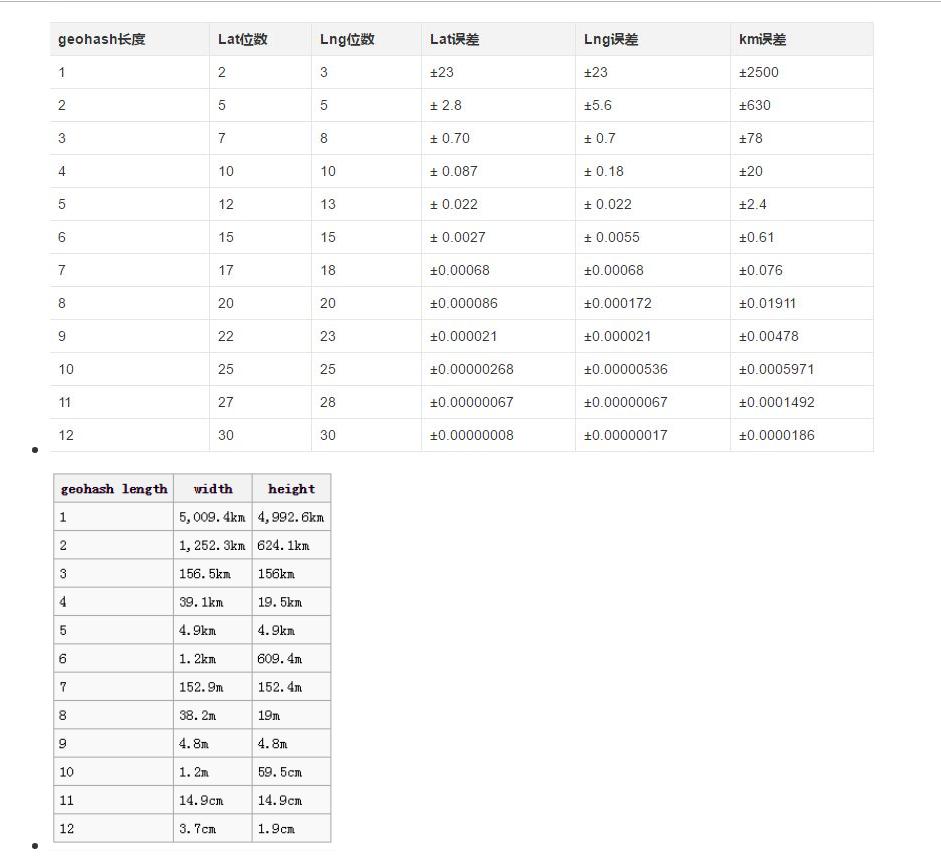
二、Geohash距离换算(使用base32编码)
如果geohash的位数是9位数的时候,大概为附近2米
| geohash length | lat bits | lng bits | lat error | lng error | km error |
|---|---|---|---|---|---|
| 1 | 2 | 3 | ±23 | ±23 | ±2500 |
| 2 | 5 | 5 | ± 2.8 | ± 5.6 | ±630 |
| 3 | 7 | 8 | ± 0.70 | ± 0.7 | ±78 |
| 4 | 10 | 10 | ± 0.087 | ± 0.18 | ±20 |
| 5 | 12 | 13 | ± 0.022 | ± 0.022 | ±2.4 |
| 6 | 15 | 15 | ± 0.0027 | ± 0.0055 | ±0.61 |
| 7 | 17 | 18 | ±0.00068 | ±0.00068 | ±0.076 |
| 8 | 20 | 20 | ±0.000085 | ±0.00017 | ±0.019 |
三、测试
<?phprequire_once('Mysql.class.php');require_once('geohash.class.php');//mysql$conf = array('host' = > '127.0.0.1','port' = > 3306,'user' = > 'root','password' = > '123456','database' = > 'mocube','charset' = > 'utf8','persistent' = > false);$mysql = new Db_Mysql($conf);$geohash = new Geohash;//经纬度转换成Geohash$sql = 'select shop_id,latitude,longitude from mb_shop_ext';$data = $mysql->queryAll($sql);foreach($data as $val) {$geohash_val = $geohash->encode($val['latitude'],$val['longitude']);$sql = 'update mb_shop_ext set geohash = "'.$geohash_val.'" where shop_id = '.$val['shop_id'];echo $sql;$re = $mysql->query($sql);var_dump($re);}//获取附近的信息$n_latitude = $_GET['la'];$n_longitude = $_GET['lo'];//开始$b_time = microtime(true);//方案A,直接利用数据库存储函数,遍历排序$sql = 'SELECT *,latitude,longitude,GETDISTANCE(latitude,longitude,'.$n_latitude.','.$n_longitude.') AS distance FROM mb_shop_ext where 1 HAVING distance<1000 ORDER BY distance ASC';$data = $mysql->queryAll($sql);//结束$e_time = microtime(true);echo $e_time - $b_time;var_dump($data);exit;//方案B geohash求出附近,然后排序//当前 geohash值$n_geohash = $geohash->encode($n_latitude,$n_longitude);//附近,参数n代表Geohash,精确的位数,也就是大概距离;n=6时候,大概为附近1千米$n = $_GET['n'];$like_geohash = substr($n_geohash, 0, $n);$sql = 'select * from mb_shop_ext where geohash like "'.$like_geohash.'%"';echo $sql;$data = $mysql->queryAll($sql);//算出实际距离foreach($data as $key =>$val) {$distance = getDistance($n_latitude, $n_longitude, $val['latitude'], $val['longitude']);$data[$key]['distance'] = $distance;//排序列$sortdistance[$key] = $distance;}//距离排序array_multisort($sortdistance,SORT_ASC,$data);//结束$e_time = microtime(true);echo $e_time - $b_time;var_dump($data);//根据经纬度计算距离 其中A($lat1,$lng1)、B($lat2,$lng2)function getDistance($lat1, $lng1, $lat2, $lng2) {//地球半径$R = 6378137;//将角度转为狐度$radLat1 = deg2rad($lat1);$radLat2 = deg2rad($lat2);$radLng1 = deg2rad($lng1);$radLng2 = deg2rad($lng2);//结果$s = acos(cos($radLat1)*cos($radLat2)*cos($radLng1-$radLng2)+sin($radLat1)*sin($radLat2))*$R;//精度$s = round($s* 10000)/10000;return round($s);}?>
四、总结
方案B的亮点在于:
1、搜索结果可缓存,重复使用,不会因为用户有小范围的移动,直接穿透数据库查询。
2、先缩小结果范围,再运算、排序,可提升性能。
254条记录,性能对比,在实际应用场景中,方案B数据库搜索可内存缓存;且如数据量更大,方案B结果会更优。
方案A:
0.016560077667236
0.032402992248535
0.040318012237549
方案B
0.0079810619354248
0.0079669952392578
0.0064868927001953
两种方案,根据应用场景以及负载情况合理选择,当然推荐方案B。
不管哪种方案,都记得,给列加上索引,利于数据库检索。
注意:在数据库中给Geohash加上索引,用户位置频繁发生改变则会导致索引重建,这势必会给数据库造成很大的压力

若有收获,就点个赞吧
0 人点赞
